A brief background
The Denmark Shire lies in the Pibbulmun cultural area which is part of the wider Noongar country region. Prior to European settlement, both Pibbulmun and Minang groups met regularly for ceremonial and economic purposes as Denmark was an area of cultural interaction. Wilson Inlet and its tributaries formed a focal point for Noongar people who managed and utilised the Inlet and its abundant natural resources. Archaeological evidence has been found, such as fish traps in Wilson Inlet and carbon from Aboriginal cooking fires identified in the sand from a cave near Ocean Beach.
Thomas Braidwood Wilson, a Scottish navy surgeon, discovered this area in 1829 when conducting an expedition from Frederickstown – later to become Albany. He came across the river here and named it the Denmark River, after Dr Alexander Denmark RN, his friend and former tutor at Naval Medical College in England. The town grew around the banks of the river and was initially known as Denmark River, but the word ‘river’ was later dropped.
The first European land use was by graziers and, in 1893, the Millar brothers set up a sawmilling operation on the Denmark River to meet the needs of the Goldfields which used huge amounts of timber … and here the story of the town of Denmark began.
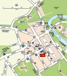
Start point – Denmark RSL Hall
Located at the corner of Strickland Street and Bent Street, Denmark RSL Hall is the starting point for your walk.
Stop 1 – St Leonard’s Anglican Church
From the RSL Hall turn left along Strickland Street and on the next corner, Mitchell Street, you will find St Leonard’s Anglican Church, built by the Church of England congregation in 1899 during the sawmilling era. It is the oldest remaining public building in Denmark and is heritage-listed.
Originally the entrance to the church consisted of nine steep steps at the eastern end but, with the difficulties that funerals presented and the hazard to elderly residents, this was moved to the western end, at ground level, in 1914. As a result, the internal design of the church had to be reversed. The Baltic pine boards which line the building had arrived as ship’s ballast from Norway and local immigrants from Scandinavia, employees of Millars (some of whom are said to have jumped ship), fixed them in place.
In 1978 the wooden ‘flying buttresses’ were added along the south side for stability, as the building was found to have moved a little after Cyclone Alby. Nowadays, as well as being used as a church, the building is also used for concerts due to the excellent acoustics. Take a look around, admiring the beautiful window and original pews. Outside there is a lovely remembrance garden as well as the ‘bell’ made from the outer flange of an old wheel.
Stop 2 – The First School
The school, known as the Mill School, was erected on the site later occupied by the Infant Health Centre and now the Denmark Arts Council. This road was not constructed until many years later and was the original playground. The principal’s house stood where the RSL Hall is now.
The school opened on 1st December 1896 with 53 children and the first headmaster was Johann Henri Otto, a Frenchman. It was built at a cost of 250 pounds and was very large for its time. Millars had also built 100 houses, a hall, church and billiards room. In 1903, Millars closed down and the school was closed on the same day and did not re-open for five years, and from 1913 it was known as the Denmark State School. The house at 11 Price Street, which was the teacher’s quarters, is the only original building still standing on the school site and is heritage-listed.
Stop 3 – London Plane Tree
Opposite the church is the site of the first Denmark Mill State School and here you will find a London Plane Tree which was planted in the grounds of the old school at about the same time as it was opened in 1896. Believed to be the oldest planted exotic tree in Denmark, this deciduous tree is found extensively around the world in streets and parks as it tolerates poor atmospheric conditions and smoke. (There is also a large fig tree in Fig Tree Square, across the other side of Strickland Street, which was planted in a private garden in 1925.)
Stop 4 – Red Cross building and CWA building
Further along Mitchell Street, the Red Cross Shop was originally a Methodist Church, built in 1927. The Country Women’s Association meet regularly in the adjacent building, part of which was an original Group Settlers house from Silver Road. The hall section was built from the first Denmark School when it was dismantled.
Group Settlements were a joint project of the Western Australian and British Governments to attempt to alleviate unemployment following World War I. There were about 20 families in each group and the 15 groups in this district brought about 1500 settlers to the area. The groups lived in shelters while clearing about 25 acres of the 200 acres allocated for each farm. Once the four-room timber house, with front and back verandahs, was built and there was a cow and a horse for each farm, a ballot was held to allocate the farms.
Because of these Group Settlements, many roads were built and a number of one-teacher schools were constructed near the settlements. The 1929 world-wide depression was the final blow for many families, who found that their allocated farms were not economically viable, and a large number simply picked up their possessions and left. Those few families who had managed to become self-sufficient were able to continue.
Stop 5 – The Waiting House
Looking across Brazier Street, on the opposite corner you will see The Waiting House, originally built in Kalgoorlie in 1910 then re-built here in 1924 to provide accommodation for women in the latter stages of pregnancy, especially those from the more remote areas of the district and in the winter months when the rivers may have made travel uncertain.
Stop 6 – The Old Police Station and Historical Museum
Cross Mitchell Street to the Historical Museum, formerly the Old Police Station, built in 1923. It consisted of a main room, four lock-up cells and an exercise yard and remained in use until 1985, when the present Police Station was opened immediately behind this building and facing South Coast Highway.
In 1983, hearing that the Old Police Station was to be demolished, the Denmark Historical Society wrote to the Minister of Police requesting that the building be transferred to the Denmark Shire Council so that it could be used for a local history museum. This request was granted and the museum displays many objects, photos, and documents, as well as about 160 oral history recordings.
Stop 7 – Randall Park
Continue along Mitchell Street, then along Short Street and when you reach South Coast Highway you will see opposite Randall Park. Just take a look at the large trees here and imagine what it must have been like when the first Europeans arrived.
The early explorers described the trees in the Denmark area as having gigantic proportions, with enormous girth and altitude. These magnificent trees were Karris, some of which may be seen in the background here. They are a species of Eucalyptus and one of the tallest forest trees in the world. These trees were to lead to the establishment of the town of Denmark, when the Millar brothers started their timber mill here. The Karri timber was largely used for railway sleepers as well as in the Goldfields and some Karri beams were also exported.
At the time Denmark was founded, the demand for timber was so high that the three sawmills (a second mill was built alongside the first and another at Scotsdale) were working night shifts by the light of kerosene lamps. By 1900, the three mills were producing over 90,000 superfeet of timber, filling about two railway trucks with dressed timber, per day. Mill hands worked 9 hours a day, 6 days a week.
Teamsters, however, worked much longer as they had to harness, unharness, feed and care for their animals. Here in Randall Park you can see a ‘whim’, which was hitched to a team of horses to drag the logs up to the nearest tramway. From a network of bush tramways, the logs were brought down to the mills and the sawn timber was then loaded onto railway trucks and transported to the port of Albany. Many of the roads we use today were built on the old tramway routes.
With this high rate of timber cutting, the resource soon ran out and in 1905 the mills closed, Denmark became a virtual ghost town and Millars started to demolish the buildings. Then Mr Alfred Randall (vegetable farmer) and Mr J D Smith (fisherman) petitioned the WA Government, who purchased the town from Millars for 50,000 pounds – acquiring the town, railway and 21,000 acres of land.
Randall Park is named after the Randall family and a gun of World War II vintage, probably a field artillery anti-tank gun, was placed here by a Mr Randall. This gun is now mounted outside the RSL Hall in Strickland Street.
Stop 8 – the Old Butter Factory
From the park, walk along Millar Street and then turn right into North Street. On the left hand side you will find the Old Butter Factory, which came about as a result of the closure of the third timber mill in March 1905. Dairying became the new industry and farmers sold their milk to the State Farm butter factory, which was on the banks of the river. By 1926, cream production was so great, due to the work the State Farm was doing to improve dairy production, that the Great Southern Butter Company, based in Narrogin, built this butter factory, which continued to operate until 1973.
The building was re-opened by Goundrey Wines in 1979 and was used as their wine-making facility until 1997. The Goundrey family also lived here, in what is now the Art Gallery. The Old Butter Factory is now a fine art and craft gallery, still owned by the Goundrey Family Trust.
Stop 9 – Fire Station
Continue east along North Street, turn left into Strickland Street. directly ahead is the old Hospital which served Denmark until the new one was opened in the Community park in 2005. Turn right into Peace Street, and on the corner of Hollings Road you will find the Fire Station.
The opening of the Kalgoorlie Goldfields in 1893 brought new demand for timber and Edwin and Charles Millar opened their first mill in Denmark, here on the west bank of the river. The mill from Torbay, halfway between Denmark and Albany, was dismantled and brought across Wilson Inlet and up the river by raft. In 1895, the mill produced the timber to build the workers’ houses and the bridge across the river. A larger mill was later built next to the original one.
The Fire Station marks the place where the first timber mill was built and the railway was extended from Torbay to this site in 1896, when a siding was built next to the mill. The creek that you can see to the north of where you are standing is called Millars Creek.
The first timber cut for export, via rail to the port of Albany, was in the form of blocks for road construction. It is said that when the flat wooden blocks replaced London’s cobblestones, the city became renowned for its quiet traffic. During World War II, Londoners used some of the tarred blocks to provide warmth for their homes after bombing during the Blitz. Someone who lived in London then tells us they were called ‘tarries’.
Cross to the other side of Hollings Road where there is a gazebo. The Denmark bridge passed through where this gazebo now stands. Off to the left is the Community Park. This was once the site of the old State Farm, set up on the banks of the river on 200 acres of land to assist the dairy industry, which was a mainstay of the district after about 1911 – and for the next 50 years. Farmers sold their cream to the State Farm and cheese was produced at a factory which stood on the other side of the river, near the Angling Club slipway.
Stop 10 – Berridge Park and the Mokare Walk
Walk south along the river, crossing South Coast Highway, and to your left, on the bank of the Denmark River, is Berridge Park, named after Denmark’s talented town gardener during the 1960s and 1970s. You can see a plaque here which marks the start of the 3 km Mokare Heritage Trail, which runs along both sides of the river crossing near the river mouth over an old railway bridge and returning over the road bridge.
Mokare was an Aboriginal guide and interpreter who accompanied Wilson on his explorations in this area. He was a member of the tribe known as Noongars and the river in the Noongar language was known as Koorabup. There is difference of opinion as to the true meaning of this name. Some say it means ‘place of the black swan’, others maintain it means ‘place of the baby brush kangaroo’, whilst still others claim it means ‘place to which we return’.
As mentioned previously, it is thought that there were Aborigines in this area about 40,000 years ago, but there is evidence of their presence possibly 3,000 years ago in the form of fish traps on the Inlet and ochre quarries. Aborigines were living on the northern and eastern shores of Wilson Inlet for some years after 1900, but no descendents of these Aborigines remain in Denmark today. European diseases took a terrible toll on the Noongars after white settlement and there are varying stories of Noongars avoiding Denmark due to some sort of taboo. There are also rumours of some Noongars being killed by white settlers. Whatever the truth, it must be acknowledged that European settlement caused the tragic disappearance of Noongar people from Denmark within less than two decades.
Stop 11 – the Hotel
Cross over Hollings Road now to the Denmark Hotel. In 1912 it was decided that a new railway station was needed and it was here, opposite the hotel carpark. A turntable was installed to enable the locomotives to turn round. The old railway bridge was upgraded and became the road traffic bridge, until it burned down in 1967. The present road bridge was built in 1968.
The Denmark Hotel was built in 1927 by John Clarke who, with his family, ran the hotel for many years and there have been many alterations to the building since then. John Clarke left a legacy to build the bandstand on the opposite side of the river and this legacy also provided money to purchase instruments to establish a School Band in Denmark – the first school band in WA.
Conclusion
To return to the RSL Hall, just walk up the steep slope of Walker Street to Strickland Street and turn left. The hall is opposite.
If you would like to know more about the history of our town, please visit the Denmark Historical Museum or look at these publications or look at The Denmark Historical Society website.
Acknowledgment
Information compiled by Denmark Tourist Bureau staff member Terrilyn Goodwin and volunteers Margaret Norcross and Rosalind Paull.
Below is an alternative map starting at Berridge Park.